
I have blog about cycling to the East and West, this post is about Cycle to Woodlands (about 20 to 25km from Sengkang).

I am training for my Round the Island trip (RTI), which will be around 130 to 150km.
By the time you read this post, I have successfully completed my first 100km target. Click on my Relive Video link on Youtube.
As I stay in Sengkang, I am more familiar with the East and North side, compared to the West side.
Refer map below, cycling route would be anti-clockwise Sengkang-Yishun-Woodlands-Mandai-Yishun-Sengkang.

Starting from (Point 1) Sengkang Swimming Complex, head towards Yishun Dam. I would recommend (Route 3, Google Map above), as it is 80% Park Connector and 20% pavement. You will loop South of Seletar airport.
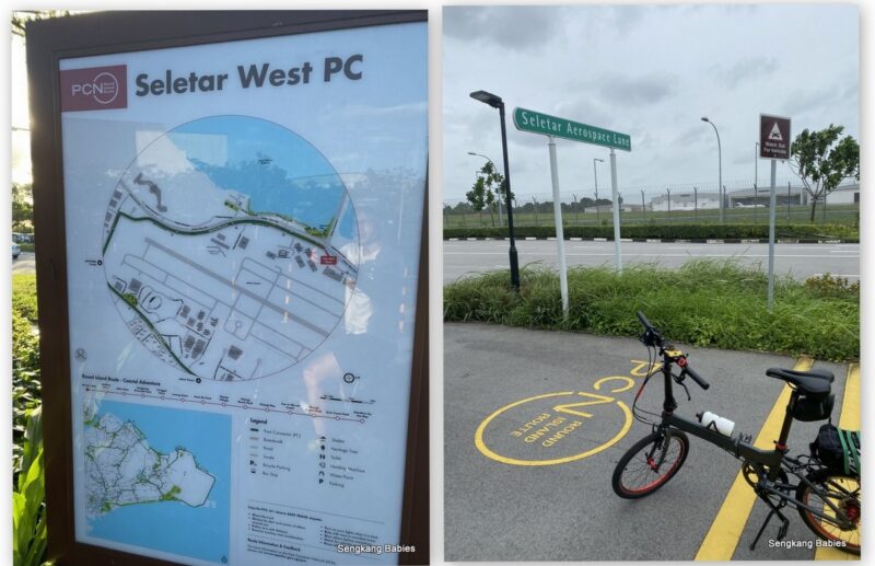
Alternate (Route 2) will bring you through sand and dusty terrain through Seletar North. The pavement is uneven and packed with construction sites (Previous experience looping around Seletar Airport)
Cycling on Seletar North road is not recommended for new riders, due to traffic and plenty of pebbles.

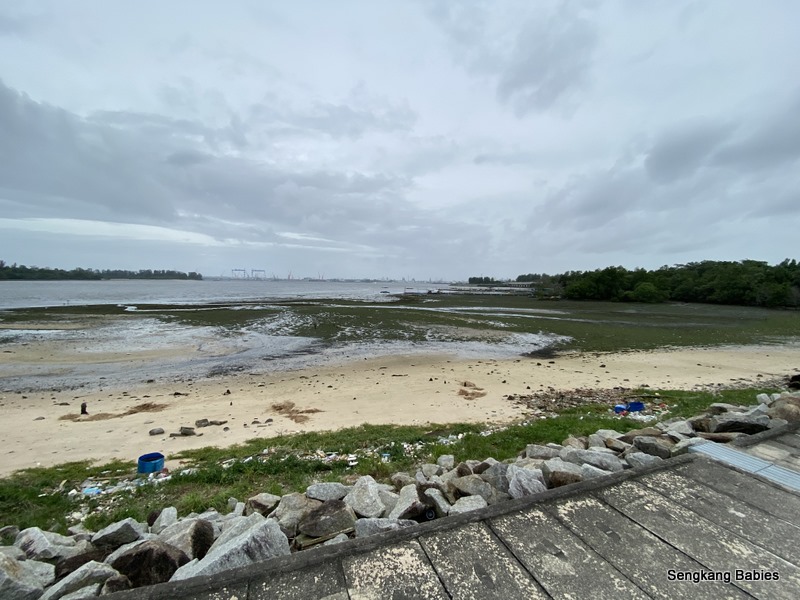
(Point 4) Yishun Dam. Take a breather and enjoy the sight, be it low or high tide.
Detour. I would recommend Rower’s Bay Park for the fantastic sunset.
This is actually one of the Coast 2 Coast checkpoints.

(Point 5) Sembawang Hot Springs. Since we cannot go to Japan or Taiwan for Onsen, this might be your open-air hot spring experience in Singapore.
(Read my Sento experience in Tokyo)
After Yishun Dam, just head North on Yishun Avenue 8 and turn left to Yishun Avenue 7.

Below photo is pre-upgrade from 2015. Only taps, no cascading pond and the kids were still so small.

Meanwhile, my first foray North was caught in a thunderstorm!

It was too late to U-turn and the rain might last hours. Totally drenched but huge sense of freedom as no more reservations. Woohoo!

Could barely see JB’s skyline. So near yet so far.

I did not expect to see so much rubbish across the straits.
If you are taking Marsiling PCN back towards Mandai or maybe Kranji. Take the path on the right side of Block 37 (picture below).

Head South along Marsiling PC followed by Woodlands PC (Park Connector), you will go behind Singapore Sports School and reach this junction (GPS).
Go across SLE and route behind MRT depot. Take note cars exiting/entering SLE travel fast, be careful. Secondly the direction from Woodlands towards Mandai, is packed with steep slopes.

(Point 8) Lastly, Ulu Sembawang is totally dark at night, and eerie 🙂
Otherwise, you should enjoy the climb and scenery. (Ulu Sembawang PCN has nice Sunrise and mist, read post here)
(fyi, Sengkang to Woodlands, you can only choose cutting across Yishun or Ulu Sembawang)
Go easy on the down slopes as the bends might block your view from runners and visitors.

Once you reach Mandai, cross the road and cycle towards Yishun, Seletar direction.
I would recommend taking the Park Connector pavement (picture below), the other side of the road is pavement (not PCN), and can be slippery (mossy) and littered with fallen branches.
Mandai Road is famous for leg and lung workout. I would recommend newbies to go in a group (and you do not need to cycle on the road).

A few openings provide scenic photo opportunities. Do look out for Pumas and Chinooks from Sembawang Air base.
You are very near to Mandai Zoo and popular T15 trail (not recommended for foldies).

SLE image below. The rain never stopped for the 2nd half of my trip.

If you are only heading towards Mandai (and not Woodlands), you can reach Mandai area via Lentor Avenue too (Take note Lentor Avenue pavement is uneven and narrow)
*If you extend your trip to Pang Sua PCN , you can connect to Choa Chu Kang, Chestnut Nature Park, Bukit Batok etc. You can also hop onto the “Coast to Coast trail” towards Jurong West (Lake Side).
Singapore is that small!

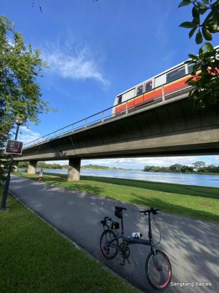
Lentor Avenue will run parallel to North-South MRT viaduct. Lower Seletar reservoir forms a nice backdrop (Location of image below).
Little kids would enjoy the wading pool at this corner, or just walk to the end of the bridge (our old blog post)

Bonus and warning, more leg trainings needed :p
If time and energy permits, you may wish to dedicate some time for the beautiful reservoirs nearby Lentor Avenue or Central Water Catchment.
Blog post – Cycle 50km to explore 3 Reservoirs and 3 parks !
Go google MacRitchie, Lower Pierce, Upper Pierce. Exercise caution along old Upper Thomson road, lookout for vehicles, monkeys and sharp hairpin turns.
Springleaf Nature Park and Thomson Nature Park are new. And take note of multiple steep slopes at the two Pierce reservoirs!

Hope you and family will have fun exploring more corners of Singapore. I might try to share some essential upgrades and basic maintenance in the next post.
Do pop by our other cycling posts too:
-Cycle 70 km East, TMCR (link)
-Cycle 80 km West, Lim Chu Kang(link)
-Cycle to Woodlands and back for 50km (link)
-Cycle 50km to explore 3 Reservoirs and 3 parks
-Completed Round Island 140km! (Click for GPX routing)
-Cycle 20km to Green Corridor (or Marina Bay and Sportshub)
-Jogging one round Sengkang, Punggol Buangkok PCN (link)
* MTB\RoadBike\Foldie selection, & Foldable bike shortlisting
* Follow my family’s cycling experience here .
-Instagram SengkangBabies #skbCycles