Cycle to Ulu Sembawang PCN if you like sunrise and mist. The pictures below will make your sweat and fatigue worthwhile.
I have briefly covered Ulu Sembawang PCN, when I blog about 50km North to Woodlands. This blog post will orientate the direction from Sengkang Punggol to Ulu Sembawang PCN
However, I would recommend folks to orientate the paths at least once during daylight.
This 2 km PCN stretch (between Mandai and Woodlands) has slopes and no lighting inside after sunset! It can get pretty eerie when you are cycling alone, even if you have a 1000 lumen torch!
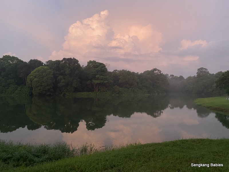
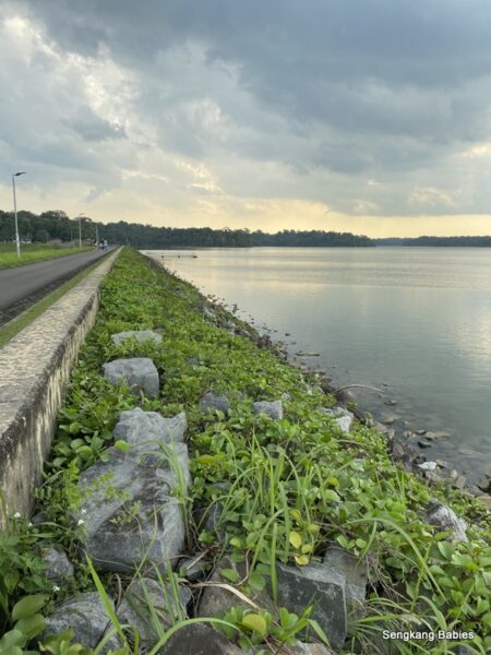
Upper Seletar Reservoir
Take note of the long slopes along Mandai Road first. As I cycled along, the orange hue sky caught up with me.
*Do take the PCN path on the left side (with respect to direction from Mandai towards BKE). The other side of the road is narrow and littered with debris (tree branches and leaves).
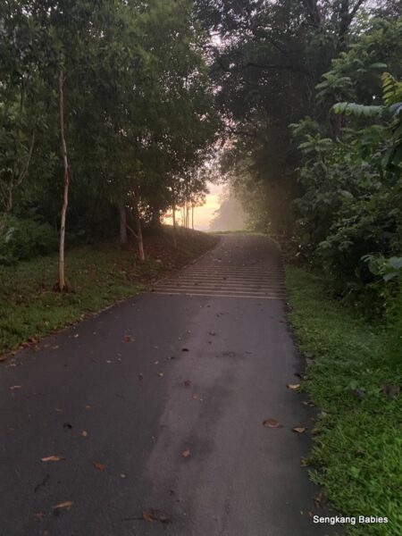
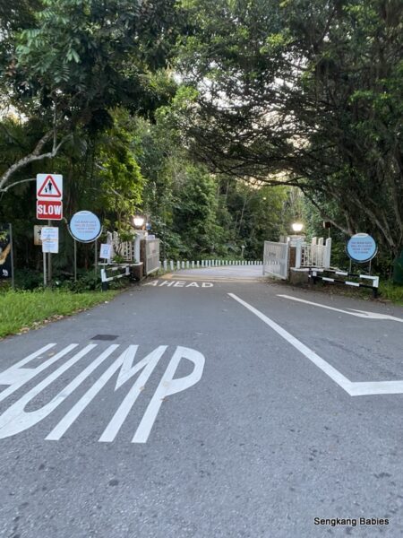
Mandai Road entrance (taken during day time). Imagine staring into pure darkness at 0600 0r 2000! Not a pleasant thought to encounter a puncture deep inside.
Another reason for company is for added protection from wild boars and dogs.
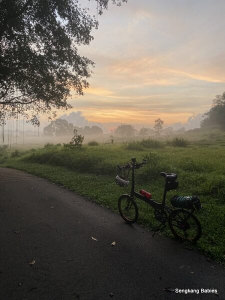
As I struggled up the slopes, the ray of lights seem to welcome me. Breathless yet full of anticipation.
Below views will revitalise your energy, the effort and sacrifice of sleep is worth it!
Cycle to Ulu Sembawang
Love the mist floating over the horizon.
Avoid weekends unless you like to jostle with crowds.
Be there at 0630, expect orange and pink hues till 0645.
Sunrise (Egg Yolk) should appear after 0655.
The mist adds to the awesome experience!
Sunrise at Ulu Sembawang PCN
On days when the forest grounds are more wet, this corridor will be covered with thick mist.
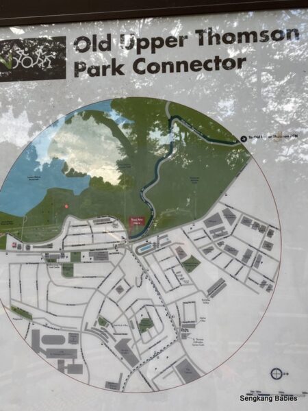
You can Cycle to Ulu Sembawang PCN from Mandai road and Woodlands Ave 12. The slopes from Woodlands entrance are tougher to overcome.
View of PCN behind Singapore Sports School, be alert when crossing under SLE viaduct, the vehicles travel fast.
Ulu Sembawang Woodland entrance
If you cycle to Ulu Sembawang from Sengkang, distance would be 17km. Regular cyclists should take 60 to 90 minutes.
Factor extra time if you are less fit, the slopes can be challenging. We would not recommend new riders to use Seletar North Link, as road has heavy traffic and many pebbles.
Refer to Google Map below, cycle along Seletar West Park Connector, detouring South of Seletar Airport.
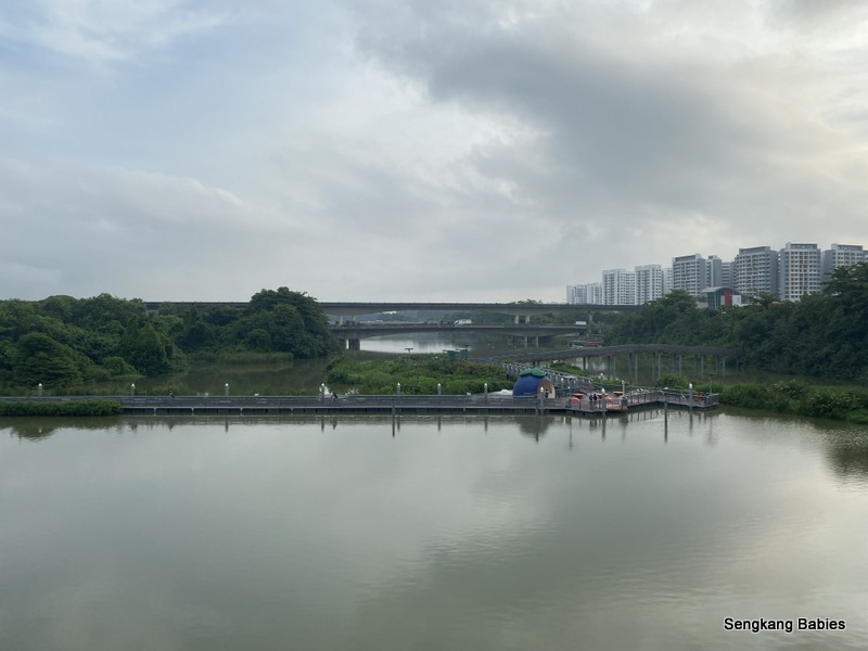
On the way back, enjoy the view of Yishun Dam. Vehicles are now packing the road. Look beyond and spot piers from “Last Fishing Village” (off access to public).
Last Fishing Village Singapore (nearest carpark at Rower’s Bay)
Cycling around the Reservoirs through Old Upper Thomson Road was on my wish list. Imagine the green views, the old road and the picturesque water and flora.
Maybe do not think about the FUN Upper Peirce Reservoirs slopes first.
You can cover 3 reservoirs in under 3 hours. If add Springleaf and Thomson Nature Park, that would be at least 5 parks or reservoirs. Adventures Buffet!
This blog post will share the attractions at each park or reservoir. You may jump down to end of page for link to more photos on our Fanpage album.
Those cycling from Sengkang and Punggol can do a clockwise Bishan Park-Lower Peirce – Upper Peirce- Upper Seletar- Springleaf -Lentor Avenue – Yishun Dam and home. Loop should be around 50km.
Cycling Sengkang to Peirce Reservoir (Cycling around the Reservoirs)
Photo below, I love the cycling tracks under Ang Mo Kio MRT viaduct (same as Bukit Batok). The pavement offers connectivity and shade.
Bishan Park
Although Sakura tree no more (Refer Nparks’ March update link), there are still plenty of visual attractions at Bishan Park.
I used to go long-kang fishing with the kids when they were younger (Blog Bishan Long Kang fish).
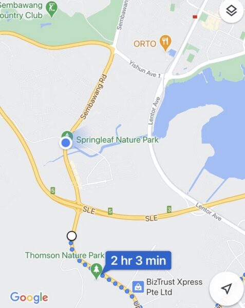
Refer to Google Map below, I had wanted to explore (1)Lower Peirce, (2)Upper Peirce and (3)Upper Seletar Reservoirs.
By all means, detour and explore scenic Springleaf Nature Park and Thomson Park too.
Did you notice Macritchie Reservoir is a mere 5km from Lower Seletar Reservoir? More corners to explore and photograph.
Lower Peirce Reservoir
Lower Peirce Reservoir is easier to access compared to Upper Peirce Reservoir ( It is about 1.5km and 3km by bus and walking, respectively.)
Lower Peirce Reservoir’s scenic offerings are not inferior and there are plenty of reflections too. Pose away.
Cycling around the Reservoirs
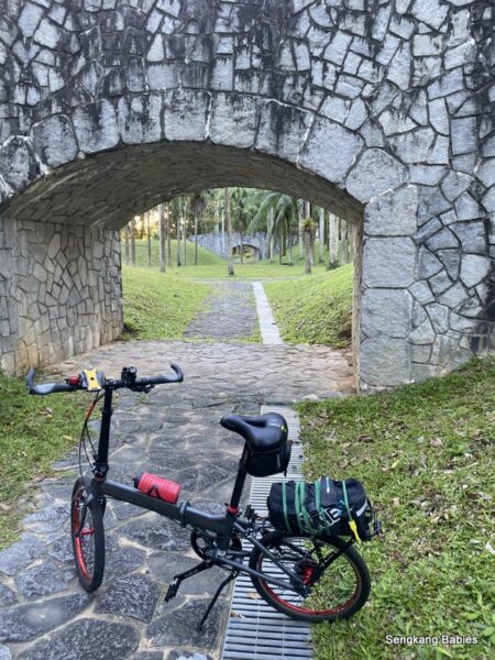
Do follow the winding trails and hug the nature. Boardwalk will let you walk along the water fringe.
Head North along Old Upper Thomson Road, and you will hit junction of Casuarina Road.
Do take note of opening hours for Nature Parks. We want the animals and insects to rest too.
It seems like we can still use the Park Connector, but the gates to the reservoirs will be locked.
PCN for joggers and cyclists, and one-way road for vehicles. I prefer to cycle on the road as it is less crowded.
Follow the meandering Old Upper Thomson road to explore nature up close. You will be connected to the reservoirs, and new Thomson Nature Park too.
Can you imagine how Grand Prix used to drift the hairpin turns in the 1960s?
No more racing on this road, but we are using 2 wheels for Cycling around the Reservoirs.
While cycling or jogging along Old Upper Thomson Road, you can detour and explore the trails at Thomson Nature Park.
Upper Peirce Reservoir
I noticed a detour (Meeting Point 7) at the entrance of Upper Peirce Reservoir. For those who relish a path (and mud) less traveled.
The slopes will take away your breath, literally. Fringed by marvelous green slopes and canopies, it is no joke to cycle up the slopes (x2 times!).
The monkeys will cheer you on :p
But the views are worth the sore calves! Cloud reflections bounced off the reservoir surface. The water is so clear we can see the bottom of the reservoirs.
This spot is super popular for fishing. I am just curious why otters do not navigate to these inland water bodies?
Loves these reservoir pockets of nature. Fresh air providing a respite from Urban landscapes. Awesome instagrammable shots.
Exit Upper Peirce Reservoir, and head towards Upper Seletar Reservoir.
If you start from Springleaf and head towards Bishan direction, you will encounter more slopes (Gut feel maybe 15% more).
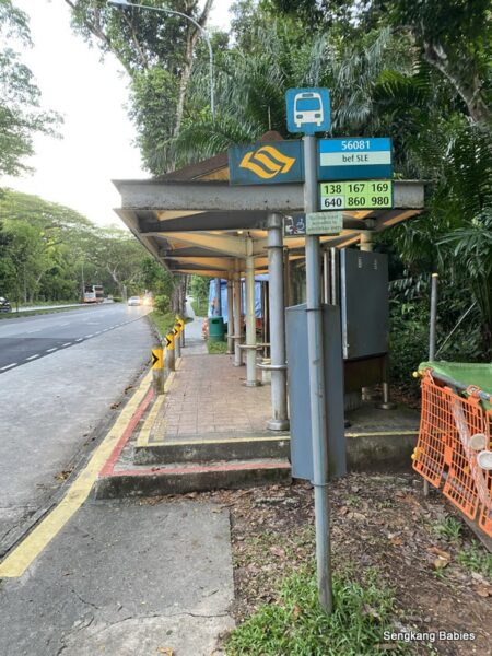
Do take note of this “bef SLE” Bus stop. You might not see the steps at night and fly off! This Bus stop is right after you exit Old Upper Thomson Road. Be careful.
Heading towards Upper Seletar Reservoir, you will pass by new MRT line Thomson East Coast line. This is Springleaf station.
I just realised Upper Thomson Road stretches from (almost) MacRitchie Reservoir to Springleaf Nature Park (about 9km).
You will pass by Springleaf Nature Park (on the opposite side), turn left into Mandai Road. (Springleaf and Thomson Nature Park are near to each other.)
Go under this underpass to reach Upper Seletar Reservoir. (GPS 1.402488, 103.812526), follow Mandai Road Track 7.
You will have to cycle on the road and up a slope.
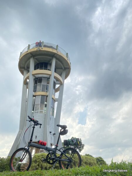
Upper Seletar Reservoir
Highlights at Upper Seletar Reservoir would be the Rocket and that Tree. Take more photos, climb to the roof for a panoramic view.
I have added Google Map GPX in this link, which links you from Sengkang to Yishun to Upper Seletar Reservoir.
Lesser crowds at Upper Seletar Reservoir, perhaps it is less accessible?
MRT will bring more folks nearer to the reservoirs in the future.
Famous Tree at Upper Seletar Reservoir
I was fortunate to catch a rainbow on 12th of July!
You can follow the path and cycle towards Mandai Road. This is more convenient compared to cycling in from Mandai Road itself.
I would not recommend this stretch for new cyclists as road is narrow. Just admire the rows of heritage trees forming a “green corridor”.
Just follow the river along Springleaf Nature Park and you will hit Lentor Avenue and Lower Seletar Reservoir.
漂亮! Nice Sunset.
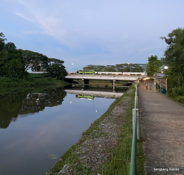
Lower Seletar Reservoir
Cycle pass Lower Seletar reservoir, catch the sunset or blue hour.
From here, you are only 10km from Punggol or Sengkang, via Yishun Dam.
Hope you would find our reservoir tips useful. Cycle to enjoy more flora and fauna. More photos on Cycling around the Reservoirs can be found on our Facebook album.
Singapore Reservoir Photos
Do pop by our other related hiking and cycling posts too:
ps.. if you cycling from Yishun Dam towards Mandai, take note Yishun Ave 1 Lane 3 is super bumpy and uneven. Ride safe.
Updated 29Aug : Thomson-East Coast Line opened in Aug 2021.
3 stations will bring you close to Bishan Park and Reservoirs! (Mayflower, Lentor and Springleaf MRT stations). This is exciting news.