Singapore Round Island Route for cycling

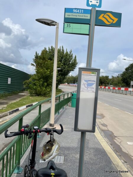
This first segment or Singapore Round Island Route is 75km, and covers Rower’s Bay, Sengkang, Punggol, Pasir Ris, Changi, Tanah Merah Coastal Road, East Coast Park, MBS, Clarke Quay, Queenstown (MRT), till Labrador Park.

*update 01FebSecond blog post (full RIR) with Strava Map is up

Second segment of Round Island Route (RIR) will only be ready in 2035. Expect park connectors (PC) and pavements to link to Lim Chu Kang and Neo Tiew road.

Cycling from Sengkang to East Coast Park via RIR (YouTube Video)

With such a big announcement, many cyclists were busy exploring the new route and detours. Alas, Nparks’ map is not really accurate, and many are left guessing with navigation.

Singapore Round Island Route

Nparks’ link and map is here, but my strava map is more accurate :p

In this post, I will only cover from Sengkang to East Coast Park.

Two highlights for me would be Sengkang Bridge and stretch along Tanah Merah Coastal Road.

With more folks exploring different segments of RIR, I would recommend that you wait for more details on the entry and exit points. This might save you some extra energy, unless you love to explore and do not mind getting lost 🙂

Getting Lost in Singapore can be Fun!
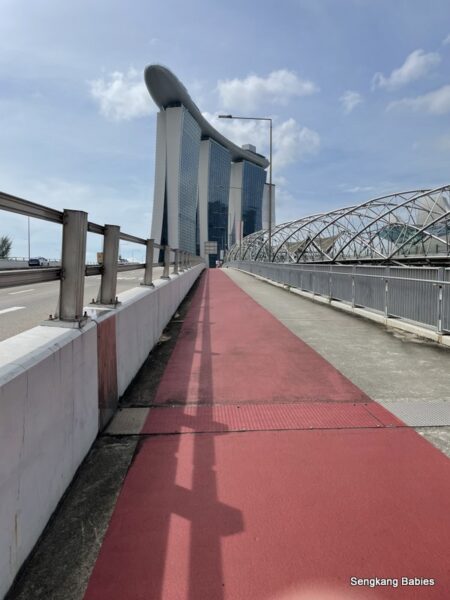
New Sengkang Bridge

This bridge has taken too long to open, many joggers and cyclists were curious about the other side of the bridge. This bridge does not disappoint.

Wide, spacious and quite scenic. If only future bridges could be this standard. Same applies for RIR’s wide passageways. Kudos!

Sengkang New Bridge is located at this spot (GPS 1.400038, 103.887772). You will need to ride up a mini slope, and bridge is just behind the toilet.

Cross Punggol’s iconic Lorong Halus Bridge to head towards Pasir Ris.

Take note after passing the PCN along Lorong Halus (towards Pasir Ris direction).

Take a left turn at the junction ( point “X” below GPS 1.383997, 103.936452). 99% of folks will turn right at this junction and head towards Downtown East direction.

You can now cut direct into Pasir Ris Park, and exit at (GPS 1.388065 103.939067).

RIR New Entry to Pasir Ris

This entry point is easy to miss, and I consider myself a regular along this stretch. Do LOOK OUT for heavy vehicles driving in and out of Pasir Ris Farmways.

Between Downtown East and Api Api river, there are at least 4 entry/exit points into Pasir Ris Park. I do not know which one is official “RIR” entry.

Please share Pasir Ris park other exit points with me 🙂

Fast forward to Changi Bay Park Connector

Shortly after Changi Ferry Terminal, turn left into the new Park Connector.
Refer my Strava Map, GPS is 1.370873, 104.004861.

Take note the trees (samplings) will need at least a few years to mature. There are minimum shelters, but there is a toilet along this 4km stretch.

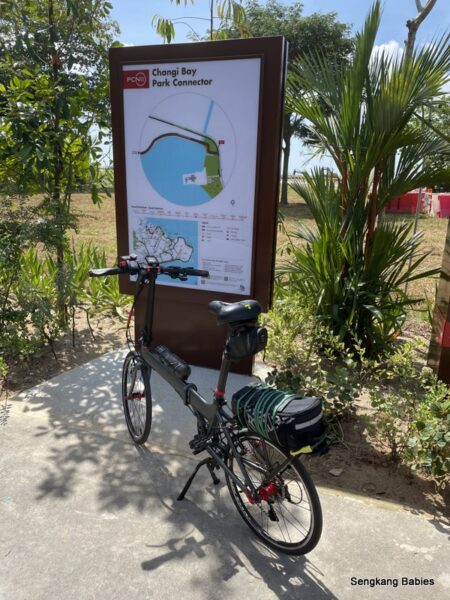
This 4km stretch might make your TMCR journey a little bit more scenic. Feels a bit like family-edition of TMCR.

Changi Bay Park Connector

Rare to find this type of under-utilised cycling route in Singapore. It would be perfect if there is more shade.

Those who wish to explore only Changi stretch, can just park at carpark next to Changi Ferry Terminal. Stretch yourself and you can reach Jurassic Mile (and Changi T2), 15km one way.

Nice image below credit my friend Eddie.

Love this small climb, slowly exposing the horizon. Suspect the sunrise at this spot should be mesmerising.

Singapore Round island Route Sunrise

This lone moon-leave tree caught my attention. It felt like the 金城武 tree in Taitung (maybe I am too imaginative). Do pop by our Taiwan Taitung cycling trip here.

金城武 tree Taitung

You will exit PC after passing by Changi Exhibition Centre, and face the boring Tanah Merah Coastal Road (TMCR) again.

Jelly fish under the bench!

Round island Route bench artwork

After Navy Museum junction, you will detour left. This is a new stretch of road and park connector, with dedicated bike lane.

Look left and enjoy the coastal view. Look right and you might identify the buildings along the “original” TMCR route.

New TMCR stretch

For those new to Tanah Merah Coastal Road, there is a parallel PCN. I was cycling on the dedicated bike lane.

Hot day, enjoyed some shade and biscuits at Coastal Park Connector.
Spot the sails and fishing along this ulu cove.

Leisurely ride into East Coast Park. Spotted some stealth otters swimming inland during high tide.

Pit stop at my favourite 7-11 along East Coast Park. Recharge with ice cream and Pocari.

Feedback for RIR:

1)Hope Nparks will add more Singapore Round Island Route markers. During my trip, I can spot many cyclists lost in Sengkang or Pasir Ris 🙂

2)We hope the trees will grow faster and provide more shade.

Serangoon Park Connector

Was supposed to cover up to MBS, but I woke up late and missed the timing. Singapore Round Island Route will be popular with cyclists and families.

More opportunities to explore all corners of Singapore.  Thank you Nparks!

Strava map Singapore Round Island Route

Updated 01Feb
The second blog post on RIR is ready, click link for blog post.

Do refer to our full RIR cycling map (Strava map here). It will help you to identify and maybe pinpoint the turns along Round Island Route.


Strava Dinosaur ride 130km

Strava Dinosaur ride was on my to do list for 2021. The only thing I needed was to find the time.

Finally took leave in December to complete the route, 130km within 10 hours. You may refer to Google Map GPX link.

My previous Strava experience was a 50km Merlion ride.

Strava Merlion Singapore GPS drawing

In summary, these were the challenges I encountered for Strava Dinosaur ride:

– I did an anti-clockwise ride. The western loops, city area, Bedok and Chai Chee slopes are best tackled with fresh legs. The eastern loop from Tanah Merah Coastal Road (TMCR) towards Changi Village and Pasir Ris, are relatively straightforward.

– Before the attempt, cyclists should be comfortable with 50km rides. 130km can be a stretch. No1 tip, DO NOT RUSH for time! And cater for plenty of rest and water.

– TMCR is 13km of boring straight ride, stretching your patience and endurance. This is especially true after you have already clocked 100km. Hope you can avoid the head winds :p

– I did not enjoy T-Rex’s “hands”. The repetitive loops in and out of East Coast Park are not fun, and Chai Chee roads are packed with slopes and single lane roads (intimidating for new riders).

How to use Strava Map (or Google Map GPX) to trace

      1. You can save Terence’s Strava map into your own Strava (then click Use Route)
      2. Or you can open Google Map GPX. Both methods allow you to trace the route turn by turn. With a map, it is still very common to miss a few turns or junctions. I will highlight a few segments in post below (Eg, I nearly cycled into an expressway!)
Strava Dino ride
Strava Dino ride


Start point 0km-Punggol Marina Club

Those living in Sengkang or Punggol can start from Punggol Marina and cycle West towards Yishun Dam direction.

At Yishun Dam, new riders should avoid the two-lane roads as vehicles can be impatient (peak hours) and cyclists do not have a lot of room to evade. Bumpy pavement is safer.

10Km Mark-Canberra

The link to Simpang Kiri PCN is still not ready.

Near Block 507B Wellington Circle. This plot of land is popular with families, kites and soccer during weekends.

20Km-lower Seletar Reservoir

Banana break, enjoy the MRT’s reflections.

Be careful along Lentor Ave’s filter for SLE, vehicles are travelling fast (Y-Junction here). Very hard to filter right here. New riders can go on the footpath.

Head South till Bishan Park, then follow Kallang River PCN. You will pass MRT depot and go up bicycle bridge near BCA Academy.

Bicycle Bridge Singapore

Kallang PCN will bring you to Potong Pasir and MOM (Balestier).

36Km-MOM (Bendemeer)

Ride safe.

The roads along Bendemeer, Balestier and Moulmein are always congested.
It is the same for Bukit Timah Road towards Ophir Road, you will pass by KK Hospital and Little India MRT.

42Km-near Rochor mrT

Pit stop for bao (Snacks) and 100 plus. Weather is warm and traffic is busy.

Head towards Singapore Flyer direction. You will go past MBS, Gardens by the Bay, Marina Barrage and Indoor stadium. This is the easy and scenic stretch.

Congrats, you have completed T-Rex’s tail and buttock already.

55Km-Circuit Road Hawker Centre Lunch

Al Fresco dining by the river at 1200 noon, gobbled down char siew rice.

From past experience, I need to keep myself hydrated and nourished, the weather can be punishing. Sugar boost with sugarcane drink.

Can feel my legs softened at 50km mark. Maybe I did not clock enough mileage post booster 🙂

65Km-Marine Parade near ECP underpass

After lunch, followed PCN till Breadtalk HQ, CDC (Comfort) then head towards Jalan Eunos (watch out for traffic).

You will cycle past Sims avenue and along Kembangan Park Connector.

You are near East Coast Park when you see this Dolphin sculpture (near Block 33).

From either direction (CW or Anti-CW), you will need to enter and exit East Coast Park twice to form T-Rex’s mini hands. There are many loops around Siglap, Katong Chai Chee, Bedok neighbourhoods.

(Photo below ) The stretch from Siglap Road towards Chai Chee Street would have many slopes.

Uphill and single lane, not recommended for new cyclists. If you are cycling on pavement, it will be bumpy as this is private estate and has many junctions and humps.

Go slow, safety first.

(Photo below) Along Bayshore Road, heading South towards condo “Costa Del Sol”. Be alert and look for the pavement behind condo (GPS 1.311490, 103.940759), which will lead to underpass.

*If you are cycling on road, you will hit the point “X” which leads to ECP expressway! Be careful if you are crossing the junction here as it is a blindspot for vehicles.

80Km-Bedok jetty

Second entry point to East Coast Park. You will cycle East and exit behind  Bedok Camp. Maybe desserts at Bedok Food Centre?

Do take note Bedok Road is also single lane, but the lane is wider. Keep left and ride safe. It will be more convenient when the PCN behind Newater Plant is ready.

This PCN will link folks in Bedok, Tampines and Pasir Ris seamlessly to East Coast Park.

The rain was falling “infront” of me, I was concerned that it will be wet and sandy ride along Tanah Merah Coastal Road (TMCR).

Well, better for the rain to be infront, instead of pouring over me.

Another impromptu pitstop at the canteen at Bedok Industrial Park E (Just before Changi Hospital’s junction). I needed to refresh before I attempt Xilin Avenue and TMCR.

Expo MRT, dark clouds loomed.

Be alert along Xilin Avenue. Whether you are heading towards ECP or Simei (either direction), the Y-junction is challenging.

Fast moving vehicles (trucks too), upslope filtering (lanes) and blindspots. Ride safe and take care of less experienced cyclists.

Refer to the two Y-junctions (mark “X”) below.

95Km-Start tmcr

Since I am doing the Strava Dino Ride, I should pose with a dinosaur.
It was a Thursday afternoon along TMCR. Even though I was on the bicycle lane, you can feel vulnerable when the endless lorries and trucks roll pass.

One of the check points for RIR 150km walk

108Km-Toilet 4

Appreciate the greens and shade 🙂

For those attempting Strava Dino ride clockwise, “Toilet 4” would be the last pitstop before you start TMCR.

At Changi Village, I am just 20km from completing my challenge.
For those regulars, you would know that even 5km can be a stretch when you are tired.

No1 tip, No Rush.

You can choose to chill at Changi Village Hawker Centre or maybe Pasir Ris Park. Take note CV does not allow you to bring foldies inside.

Congrats, you have completed Dinosaur Head (T rex)


Take note that Pasir Ris Drive 3 is full of road works, leading to uneven pavement and road congestion. The metal plates are dangerous for bicycle wheels and can be slippery during rainy days.

-Try shortcut behind Loyang Tua Pek Kong temple (Google Map link , skip Loyang slopes)
-Take a small detour and cycle parallel along Pasir Ris Park, exit here (slope at Overseas Family School) or here

Follow the pavement, enter Lor Halus Park Connector at the bend (GPS), slow and easy back to Punggol edge (Lorong Halus bridge).

Punggol red bridge

128Km-Near Punggol Marina club

Punggol dormitories

Strava Dinosaur ride completed!

It took me almost 10 hours. Something fun and novelty, happy to cap another cycling episode. (Thank you to Terence and other cyclists for their creative Strava maps)

Strava Dinosaur ride

Tips and next challenges:

1)During the ride, I have cycled on many PCN and shared paths.

The worst “shared paths” could be those outside Yishun and Khatib MRT.  Narrow, bumpy, sharp turns and tons of speed bumps. Very uncomfortable ride experience along these tracks. Somehow, the pedestrian pavement is much smoother than cyclist track.

Are the designers and architects of these after-thought tracks even cyclists? 

Compared Yishun with Canberra’s shared paths. Which is spacious, smooth and clearly demarcated. I hope future towns will have better shared paths.

Punggol New Town
Punggol New Town

2) Do bring power bank and light (for rain or evenings)

3) Next up for 2022 Q1 and Q2, I will be walking Singapore (150km) with a few kakis, hoping to complete the loop by early April.

Class 2b license Singapore

4) Cycling has also reignited my freedom spirit, will be attempting to get a Class 2B license. Riding a motorcycle is different from driving a car. The sense of liberty and freedom….